
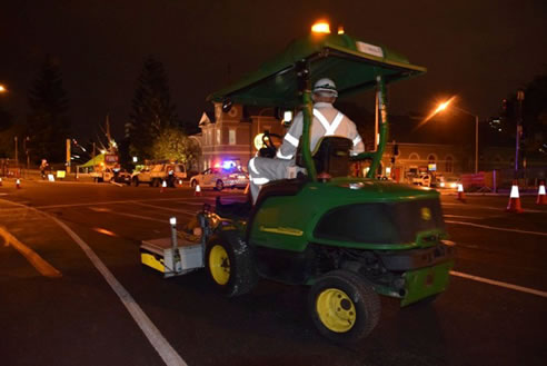
Geophysical Surveys with Concrete Scanning from ScanMan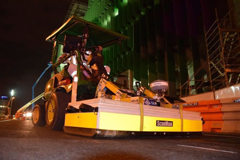 3D Multichannel Ground Penetrating Radar Survey overview The Client was upgrading the road and wished to perform some deep pavement profiling. It has been requested that the contractor undertakes a 3D Ground Penetrating Radar (GPR) survey to investigate the location of possible shallow services / Obstacles (within 500mm of surface) which might cause delays during the profiling works. This shallow set up can also be used on most surfaces including concrete & structures, For deeper Surveys we can simply use different Antennae's with lower frequency for more penetration. The delineation of subsurface features such as these requires high-resolution data with dense spatial sampling, which only few geophysical methods can satisfy. The geophysical method utilised was Ground Penetrating Radar (GPR). The aim of the survey was to provide site characterisation information and detail, which will contribute to existing site, plans; thereby providing a safer working environment and detail for informed decision making. This Scanman System is the most technically advanced GPR system on the market. It is the only system of its kind that integrates acquisition, processing, QA/QC, positioning data, interpretation and export of ground penetrating radar data. The survey was conducted by mounting instrumentation on a 4WD mower.
|
0420 307 226 249 Towen Mountain Road, Towen Mountain, QLD, 4560
|

Related News Articles
 Nationwide Ground Penetrating Radar
 Structural Scanning & X-ray Services by
 Concrete Scanning Brisbane - X-Ray
 Surface Penetrating Radar Equipment
 Surface Penetrating Radar Equipment
 Detecting Leaking Pipes Brisbane |
 Detecting Leaking Pipes Brisbane |
 Underground Scanning Services Brisbane |
 Underground Scanning Services Brisbane |
 Surface Penetrating Radar Brisbane |
 Surface Penetrating Radar Brisbane |
 3D Underground Scanning Services
 3D Underground Scanning Services
 Bore Hole Safety Check | Scan Man
 Bore Hole Safety Check | Scan Man
 Underground Cable Location | ScanMan
 Underground Cable Location | ScanMan
 Concrete Scan/Xray Queensland from
 Concrete Scan/Xray Queensland from
 Underground Cable Locating Equipment
 Underground Cable Locating Equipment
 Ground Penetrating Radar Brisbane from
 Ground Penetrating Radar Brisbane from
 Concrete X-Ray Brisbane from ScanMan
 Concrete X-Ray Brisbane from ScanMan
 3D Imaging Services Sunshine Coast from
 3D Imaging Services Sunshine Coast from
 Utility Locators Sunshine Coast from
 Utility Locators Sunshine Coast from
 Underground Locators Gold Coast from
 Underground Locators Gold Coast from
 GPR Services Gold Coast from ScanMan
 GPR Services Gold Coast from ScanMan
 Concrete Testing Services Gold Coast
 Concrete Testing Services Gold Coast
 Concrete Scanning Brisbane from ScanMan
 Concrete Scanning Brisbane from ScanMan
 |
 |
Home | About/Services | News Lounge | News Archive | Product Archive | Tender News | Testimonials | Conditions of Use | Privacy Policy | Stats
![]()
![]()
![]()
![]()
© SPEC-NET