
3D Underground Mapping and Imaging Services from ScanMan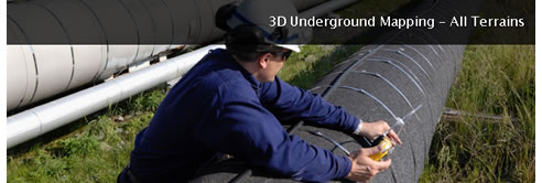 Knowing what's underneath the ground on a job site not only saves time and money, but is fast becoming a requirement of many developers and government bodies. Locating and identifying underground facilities, especially in large or highly congested areas has just gotten easier. A new technology, called 3D Underground Imaging lets you see in three dimensions what lies beneath the surface. 3D underground mapping and 3D Imaging produces three dimensional data representations of features such as buried utilities, buried debris, storage tanks, rock formations, even voids. A Whole New Dimension 3D Underground Imaging adds another dimension to already robust Subsurface Utility Engineering (SUE) locating and mapping capabilities. In some situations, especially in areas with few anticipated underground facilities, the more conventional subsurface concrete scanning or GPR, locating and mapping services are all that's necessary. However, in areas with a known high volume of underground facilities - such as in highly urbanized areas with multiple buried utility lines - two dimensional technologies may fail to detect some features due to interference caused by the heavy congestion. That's when 3D Underground Imaging excels, because it "sees" in three dimensions, providing a more accurate and comprehensive view of below ground structures and making it an ideal alternative in areas with a high degree of underground congestion or complexity. 3D mapping is able to cover a large amount of area quickly. 3D Underground Imaging is much quicker than its two dimensional counterpart in identifying below ground structures, making it potentially more cost-effective when working in larger areas.
|
0420 307 226 249 Towen Mountain Road, Towen Mountain, QLD, 4560
|

Related News Articles
 Nationwide Ground Penetrating Radar
 Structural Scanning & X-ray Services by
 Concrete Scanning Brisbane - X-Ray
 Surface Penetrating Radar Equipment
 Surface Penetrating Radar Equipment
 Detecting Leaking Pipes Brisbane |
 Detecting Leaking Pipes Brisbane |
 Underground Scanning Services Brisbane |
 Underground Scanning Services Brisbane |
 Surface Penetrating Radar Brisbane |
 Surface Penetrating Radar Brisbane |
 3D Underground Scanning Services
 3D Underground Scanning Services
 Bore Hole Safety Check | Scan Man
 Bore Hole Safety Check | Scan Man
 Underground Cable Location | ScanMan
 Underground Cable Location | ScanMan
 Concrete Scan/Xray Queensland from
 Concrete Scan/Xray Queensland from
 Geophysical Surveys with Concrete
 Geophysical Surveys with Concrete
 Underground Cable Locating Equipment
 Underground Cable Locating Equipment
 Ground Penetrating Radar Brisbane from
 Ground Penetrating Radar Brisbane from
 Concrete X-Ray Brisbane from ScanMan
 Concrete X-Ray Brisbane from ScanMan
 3D Imaging Services Sunshine Coast from
 3D Imaging Services Sunshine Coast from
 Utility Locators Sunshine Coast from
 Utility Locators Sunshine Coast from
 Underground Locators Gold Coast from
 Underground Locators Gold Coast from
 GPR Services Gold Coast from ScanMan
 GPR Services Gold Coast from ScanMan
 Concrete Testing Services Gold Coast
 Concrete Testing Services Gold Coast
 |
 |
Home | About/Services | News Lounge | News Archive | Product Archive | Tender News | Testimonials | Conditions of Use | Privacy Policy | Stats
![]()
![]()
![]()
![]()
© SPEC-NET